

Activator Toolkit for SOTA & POTA
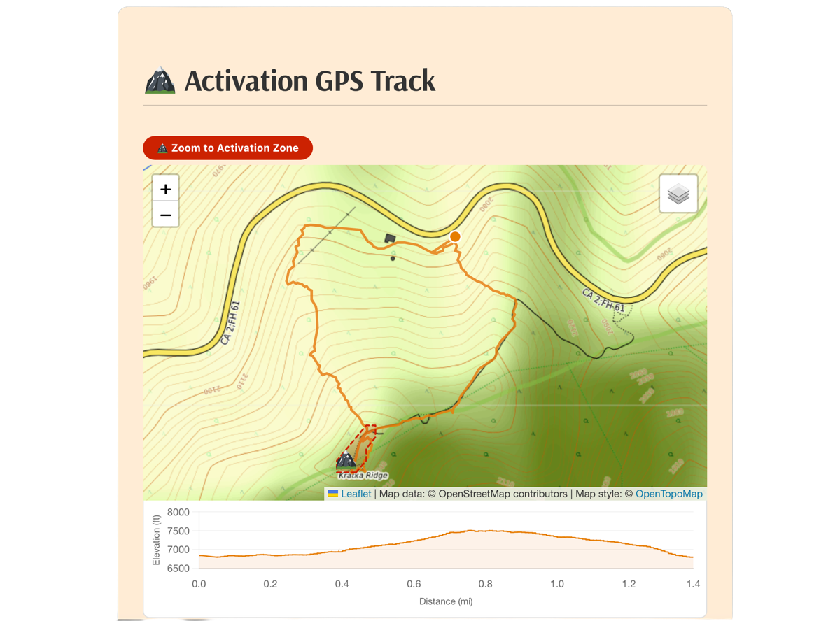
SOTA: GPX track map with elevation chart and "Zoom to Activation Zone" button
Activator Toolkit is a WordPress plugin for amateur radio operators who activate summits for Summits on the Air (SOTA) or parks for Parks on the Air (POTA). Add the Activator Toolkit block to any post or page, pick SOTA or POTA with the toggle at the top of the block, upload your files, and the plugin builds the rest.
In SOTA mode, upload your GPX track and your activation log (SOTA CSV, ADIF, or ADI). You get:
- An interactive map of your hike with three base layers (Topographic, OpenStreetMap, Minimal)
- An elevation profile chart that tracks your position on the map as you hover
- The summit’s activation zone drawn on the map, with a “Zoom to Activation Zone” button
- Hiking statistics: hiking time, activation time, total time, elevation gain and peak, hiking speed, and total distance
- A contacts table with Summit-to-Summit (S2S) contacts highlighted
- An interactive contact map showing where every station you worked was located
In POTA mode, upload the ADIF log you submit to pota.app. You get:
- Your park (or parks) named at the top, looked up automatically from the official POTA park list
- An interactive contact map with a pin at your park and a line to every station you worked
- Park-to-Park (P2P) contacts placed at the other station’s park and marked with a P2P badge
- A contacts table with a “Their Park” column and P2P contacts highlighted
- Support for activating several parks at once from the same spot
Both modes show a “Furthest contact” tile on the contact map, and hovering a row in the contacts table highlights that station on the map.
Your existing posts are safe. Every block created before POTA support was added stays in SOTA mode. Only blocks you switch to POTA render as POTA.
No other plugins required. All map and chart libraries (Leaflet 1.9.4, Chart.js 4.5.1) are bundled with the plugin.
Features
- SOTA / POTA Toggle: Each block has its own SOTA or POTA mode, so one site can mix summit and park posts. Choose which mode new blocks start in under Settings Activator Toolkit General.
- GPX Track Map (SOTA): Interactive Leaflet map with Topographic, OpenStreetMap, and Minimal base layers
- Elevation Chart (SOTA): Profile chart below the map; hover to see a position dot move along the track
- Activation Zone Overlay (SOTA): The most detailed zone available is used automatically: SOTLAS terrain zones first, then Activation.Zone (by N6ARA), then a simple radius circle. You can override the source per post.
- Intelligent Track Analysis (SOTA): Splits your outing into hiking time and activation time, with rest breaks tracked separately
- Park Lookup (POTA): Your park reference is read from the log (MY_SIG_INFO or MY_POTA_REF) and the park’s name and location come from the POTA park database
- Park-to-Park Detection (POTA): Contacts who logged their own park are highlighted, placed at that park on the map, and shown with a P2P badge
- Multiple Log Formats: SOTA CSV v2, ADIF (.adif), and ADI (.adi); the format is detected automatically
- Interactive Contact Map: Lines from your summit or park to every contact, colored by band, with a Furthest Contact tile and a list of any stations that could not be located
- Smart Station Locations: Grid squares from your log are used first; otherwise the plugin looks up the callsign with Callook.info (free, US), HamQTH (free account, worldwide), or QRZ.com (XML subscription)
- Locations Saved at Activation Time: Each station’s location is stored, so your map keeps showing where they were on the day of the activation even if they move later
- Metric or Imperial Units: km, m, km/h or mi, ft, mph
- Fully Customizable: Colors, S2S and P2P highlight colors, headlines, block width, and fonts in Settings Activator Toolkit
- Block Editor Friendly: Simple Gutenberg block with file upload, auto-detected summit or park reference, and manual override fields
- Responsive Design: Works on phones and desktops
How Activation Time is Calculated (SOTA)
The plugin finds the summit’s activation zone, then counts any time your GPS track spends inside it as activation time. It looks for the zone in this order:
- SOTLAS: Terrain-based zone boundaries at roughly 1 meter detail, when SOTLAS has them for the summit.
- Activation.Zone: Terrain-based zone from the Activation.Zone API by N6ARA, based on elevation data and the official SOTA 25m vertical drop rule.
- Radius circle: A configurable circle (default 50m) around the highest point of your track, used when neither service has a zone for the summit.
You can force a specific source for any post in the block’s Statistics Overrides panel.
How POTA Mode Works
POTA mode is driven entirely by your log file. Upload the ADIF log you submit to pota.app and the plugin:
- Reads your park reference from the log (for example US-8144). For a multi-park activation, list several parks separated by commas.
- Looks up each park’s name and official location from the POTA park database.
- Places a pin at your park and draws a line to each station you worked.
- Places Park-to-Park contacts at their park, and everyone else at their grid square or callsign location.
POTA does not publish park boundaries, so there is no activation zone in POTA mode. Each park is shown as a single pin at its official location.
Supported Log Formats
SOTA CSV v2 (the format exported from SOTA logging apps and submitted to sota.org):
V2, MyCall, MySummit, Date (DD/MM/YY), Time, Frequency, Mode, TheirCall, TheirSummit, Comments
ADIF / ADI: Standard amateur radio log files exported from logging software such as HAMRS, Polo, WSJT-X, Log4OM, MacLoggerDX, and most others. Both .adif and .adi file extensions are accepted, and the format is detected automatically. POTA mode reads the standard POTA fields (MY_SIG / MY_SIG_INFO / MY_POTA_REF for your park, SIG / SIG_INFO / POTA_REF for the other station’s park).
Requirements
- WordPress 6.0 or later
- PHP 7.4 or later
- A QRZ.com XML subscription is optional. Free Callook.info and HamQTH lookups are tried first.
External Services
This plugin connects to the following external services. By using this plugin you agree to their respective terms.
SOTA API (api2.sota.org.uk)
SOTA mode only. Used to retrieve official summit coordinates for the summit marker and Summit-to-Summit contact locations. No authentication required. No personal data is sent.
Terms: https://www.sota.org.uk
SOTLAS activation zones (az.sotl.as)
SOTA mode only. Used to retrieve high-detail activation zone boundaries for a summit. Only the summit reference is sent. Results are cached for up to a year.
Terms: https://sotl.as
Activation.Zone API (api.activation.zone)
SOTA mode only. Used to retrieve the activation zone for a summit when SOTLAS has none. The summit reference, coordinates, and elevation are sent. Created by N6ARA.
Terms: https://activation.zone
POTA API (api.pota.app)
POTA mode only. Used to look up a park’s name and official location from its park reference (for example US-8144). Only the park reference is sent. Results are cached for 90 days.
Terms: https://pota.app
Callook.info (callook.info)
Used to look up the location of US callsigns for the contact map when the log has no grid square. Only the callsign is sent. No account required.
Terms: https://callook.info
HamQTH (www.hamqth.com)
Used to look up callsign locations worldwide when HamQTH credentials are entered in settings. Your HamQTH username and password are sent to HamQTH for authentication.
Terms: https://www.hamqth.com
QRZ.com XML API (xmldata.qrz.com)
Used to look up callsign locations when QRZ credentials are entered in settings. Your QRZ username and password are sent to QRZ.com for authentication.
Terms: https://www.qrz.com/page/terms_of_service.html
OpenStreetMap tile servers (tile.openstreetmap.org)
Used for the OpenStreetMap and Minimal base map layers. Standard tile requests, including your visitors’ IP addresses, are sent to OpenStreetMap servers.
Terms: https://wiki.osmfoundation.org/wiki/Terms_of_Use
OpenTopoMap tile servers (tile.opentopomap.org)
Used for the Topographic base map layer. Standard tile requests are sent to OpenTopoMap servers.
Terms: https://opentopomap.org/about
Privacy Policy
Activator Toolkit does not collect, store, or transmit any personal data beyond what is described in the External Services section above. GPX and log files are stored in your WordPress media library and processed on your own server. Lookup service credentials are stored in your WordPress options table and are only ever sent to the service they belong to.